7 Area-based conservation and sustainable use as part of integrated ocean management
Chapter 5 of this white paper gives an account of value creation in Norway’s ocean industries, and describes a continuous increase in activity levels in Norwegian waters. The growth in activity requires access to new areas of ocean space. The most intensively used part of Norwegian waters is the North Sea–Skagerrak management plan area. This is one of the most heavily trafficked areas in the world, with a large volume of shipping and considerable fisheries activity. The North Sea is Norway’s most important petroleum province, and is also becoming an important area for the development of offshore wind power and CO2 storage. The Norwegian Sea is important for the fisheries and petroleum activities, and may also become important for seabed mineral extraction in the long term. In the Barents Sea–Lofoten area, the fisheries are the dominant industry, while the petroleum industry is growing.
In all three management plan areas, ecosystem condition and the distribution of habitat types, species and populations is being affected by climate change. Climate and environmental change combined with rising activity levels is reinforcing the need for sound management of Norway’s ocean areas to ensure sustainable use, conservation, predictability and a long-term perspective, and to avoid conflict between sectors in the future.
Marine spatial management tool
The spatial management tool for the ocean management plans is a map portal that provides information on industrial activities, species and habitats and regulatory measures in these areas. It was developed to support sound spatial management in the management plan areas, and is designed to be useful for the authorities, the business sector, interest organisations, other users of Norway’s waters and the general public.
The spatial management tool contains geospatial data sets for natural resources, commercial activities, species and habitats, plans and regulatory measures, relevant reference data and basic marine data.
The Nordic Council of Ministers has allocated funding for the development of a similar tool for the Baltic Sea, a project involving several countries. The project manager is the Norwegian Mapping Authority, while BarentsWatch is the technical supplier and user contact. The main focus of the project is valuable and vulnerable areas and offshore wind.
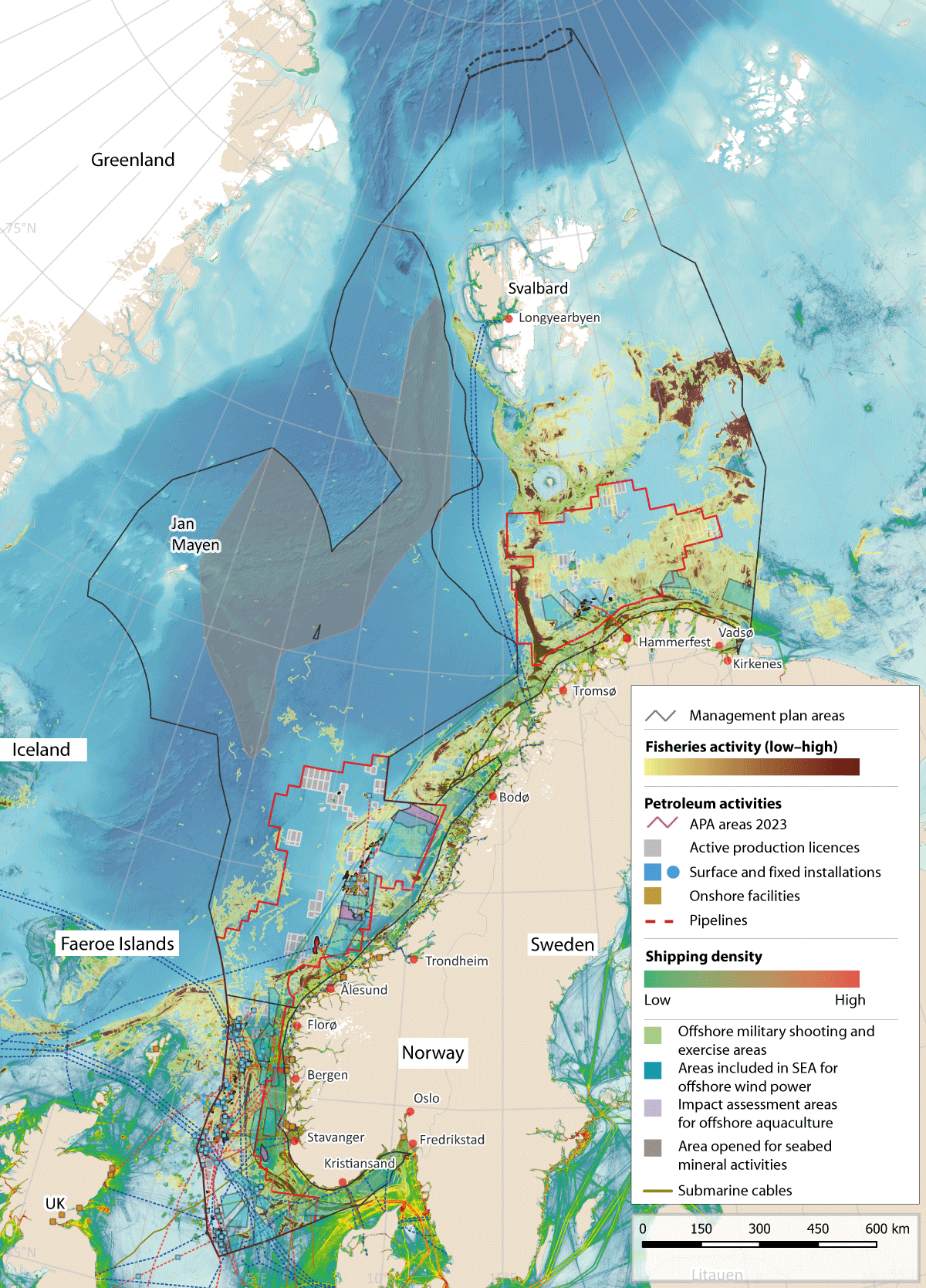
Figure 7.1 Overview of activity in the management plan areas.
Source: Directorate of Fisheries, Norwegian Coastal Administration, Norwegian Environment Agency, Norwegian Water Resources and Energy Directorate, Norwegian Offshore Directorate/Marine spatial management tool. Base map for the marine spatial management tool: GEBCO Compilation Group and Norwegian Mapping Authority
Particularly valuable and vulnerable areas
The particularly valuable and vulnerable areas have been one of the main elements of the management plan system since it was initiated with the preparation of a scientific basis and then, in 2006, the first management plan for the Barents Sea–Lofoten area. These areas have been identified as containing the most important ecological features in Norwegian waters, and knowledge that has been built up about them provides a sound basis for political assessments and decisions on the management plans. The new set of particularly valuable and vulnerable areas identified in Norwegian waters is further discussed in Chapter 4.
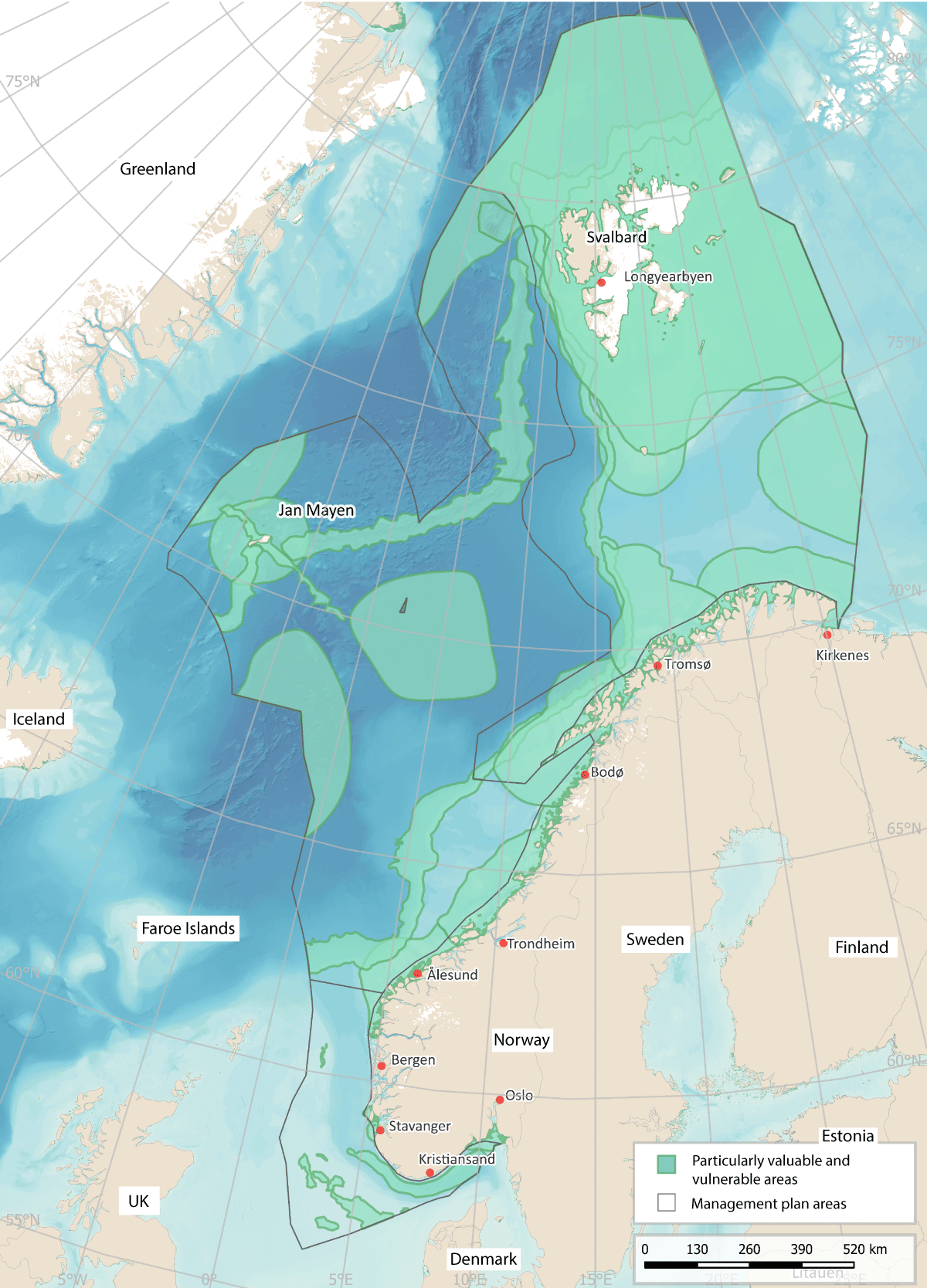
Figure 7.2 The particularly valuable and vulnerable areas identified in the three ocean management plans.
Source: Forum for Integrated Ocean Management/Institute of Marine Research/Norwegian Environment Agency/Marine spatial management tool
7.1 Ocean management in Norway and its implications for regional growth and development
Norway’s national ocean policy is developed through cooperation between central government, county and municipal authorities. Marine spatial planning and developments on land are closely linked. Decisions on where to site activities at sea may have major implications for developments at municipal and county level on land. At the same time, ocean-based commercial activities are dependent on infrastructure on land, including ports, transport networks and emergency preparedness and response resources.
Central government authorities are responsible for spatial management in waters beyond the geographical scope of the Planning and Building Act, which extends to one nautical mile beyond the baseline. Insides this limit, municipal authorities are responsible for spatial management under the Planning and Building Act. Other legislation also contains provisions that have implications for spatial management along the coast, including the Act relating to ports and navigable waters, the Security Act, the Marine Resources Act and the Aquaculture Act.
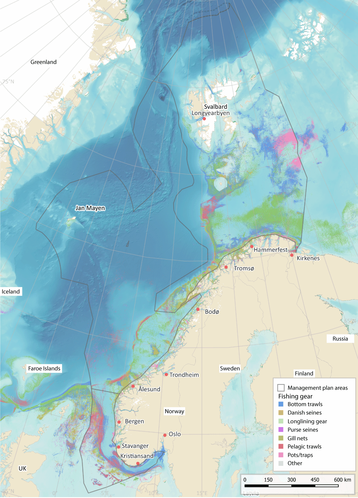
Figure 7.3 Map of fisheries activity in Norwegian waters
Source: Directorate of Fisheries/Norwegian Environment Agency/Marine spatial management tool
7.2 Designating marine space for different uses
Authorities in different sectors are responsible for decisions on which parts of marine space are to be allocated to different types of activities under the legislation they administer.
7.2.1 Fisheries
The level of fisheries activity varies over the year, from year to year, and with stock development and changes in distribution and migration patterns. Fishing grounds are not clearly delimited areas. Regulatory measures and spatial needs vary from one type of fishing gear to another. The distribution of some species, for example herring, is highly dynamic. In addition, changes are being observed in the distribution and migration patterns of many fish species as a result of climate change.
Currents along the Norwegian coast often form eddies rich in plankton and nutrients in the shallow bank areas. The availability of food and good light conditions result in high densities of fish locally in these waters. In addition, bottom conditions are favourable for the use of fishing gear, and the bank areas are therefore important fishing grounds.
The use of marine space by the fisheries is regulated under the Marine Resources Act.
7.2.2 Offshore aquaculture
There has been growing interest in offshore aquaculture in recent years. This is explained by a need for more marine space and by environmental and disease problems in a number of the areas currently used for aquaculture. The Government’s policy is to develop a separate licensing system for offshore aquaculture, including strict requirements relating to biodiversity and the coexistence of different ocean industries. The Ministry of Trade, Industry and Fisheries is coordinating the development of a licensing system for offshore production of salmon, trout and rainbow trout.
At present, there are no aquaculture establishments outside the baseline. On 1 November 2022, the King in Council decided that an impact assessment for offshore aquaculture should be carried out for three areas, in the southern Norwegian Trench, the northern part of the Frøyabanken bank area and the Trænabanken bank area. The sizes of these areas are as follows:
-
Norwegian Trench south: 485 km2
-
Frøyabanken north: 2327 km2
-
Trænabanken 4698 km2.
Once the impact assessment has been completed, decisions on whether to open these areas or parts of them for offshore aquaculture will be taken by the King in Council.
In autumn 2023, the Directorate of Fisheries authorised the use of an offshore area in Norwegian waters for aquaculture establishments for the first time. This process makes it possible to use development licences that were provisionally issued in 2019 for the development of technology for offshore aquaculture establishments.
Environmental conditions at offshore aquaculture establishments will be more difficult than at the conventional coastal locations currently in use. The design and operation of offshore aquaculture establishments must be adapted to conditions in the open sea. Wave action, current conditions and temperatures affect fish welfare and growth. This has implications for which areas are suitable for offshore aquaculture.
If aquaculture establishments are sited further out from the coast, new conflicts of interest are likely to arise with the traditional fisheries, shipping and offshore wind farms.

Figure 7.4 Areas where impact assessments for offshore aquaculture are being carried out in Norwegian waters.
Source: Directorate of Fisheries/Norwegian Environment Agency/Marine spatial management tool
7.2.3 Petroleum activities
Petroleum infrastructure, including surface and subsea installations, pipelines and safety zones around installations, occupies large areas. Areas affected by operational discharges from petroleum activities are generally restricted to the seabed in the immediate vicinity of installations and the water column within a few kilometres of them. Any major oil spills from the petroleum industry could potentially affect wider areas. In addition to the permanent installations, seismic surveys occupy considerable areas while they are in progress. Seismic surveys are carried out at all stages from exploration to final production. Even though they only last for a relatively short time in each phase, seismic surveys are the activity type that leads to most conflict with the fisheries. Delaying seismic surveys can be extremely costly for the petroleum industry. Processes have been established to reduce conflict between the fisheries and the petroleum industry (see Box 7.1).
At the beginning of 2024, 92 oil and gas fields on the Norwegian continental shelf were in production: 69 in the North Sea, 21 in the Norwegian Sea and two in the Barents Sea.
Most of the areas that have been opened for petroleum activities are now included in the system of awards for predefined areas (APA system), which is used for licensing in mature areas of the continental shelf. The petroleum industry is described further in Chapter 5.
Textbox 7.1 Seismic surveys and fisheries interests
Over time, the authorities have introduced a number of amendments to the petroleum legislation to take fisheries interests into account. There are now requirements for seismic vessels to be tracked and to carry fisheries experts on board, and temporal and spatial restrictions on seismic data acquisition. One important step is the introduction of requirements to use soft-start procedures (which ramp up the sound intensity gradually). The authorities and the employer and industry organisation Offshore Norge have each published guidelines on coexistence between the fisheries and petroleum industries in connection with seismic surveys. The Petroleum Act also includes provisions on compensation to Norwegian fishermen in the event of financial losses incurred as a result of activities including seismic surveys.
Routines have also been established for resolving disagreements between the Norwegian Offshore Directorate and the Directorate of Fisheries. If the Directorate of Fisheries has objections to a planned seismic survey, these are forwarded to the company that sent notification of the plans, so that they can be adjusted. If the Offshore Directorate and the Fisheries Directorate disagree on whether a survey should be carried out as planned, the case is referred upwards to the offices of the directors general in the two directorates. If they are unable to reach agreement, the Offshore Directorate refers the case to the Ministry of Energy, which makes a decision in consultation with the Ministry of Trade, Industry and Fisheries.
To improve communication, the Norwegian Offshore Directorate, the Fisheries Directorate and the Institute of Marine Research hold joint meetings with the petroleum industry before the start of the seismic survey season. This improves understanding and cooperation between the authorities and licensees. Offshore Norge also holds an annual conference on fish and seismic activities, which serves as an arena for the exchange of experience and communication between the two industries and the authorities.
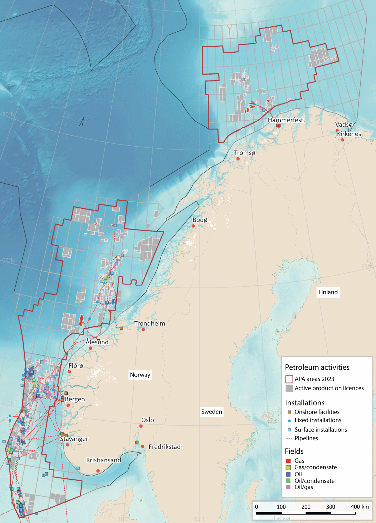
Figure 7.5 Petroleum activity on the Norwegian continental shelf.
Source: Norwegian Offshore Directorate/Norwegian Environment Agency/Marine spatial management tool
7.2.4 Offshore wind power
Norway has large marine areas with good wind resources, but a considerable proportion is only suitable for floating wind power. Two areas, Sørlige Nordsjø II and Utsira Nord, were opened for offshore wind power in 2020. These areas cover 2691 km2 and 1010 km2 respectively. In addition, 11 wind turbines are in operation at the Hywind Tampen wind farm, which supplies electricity to two oil fields in the North Sea.
The area needed to develop 30 GW of production capacity for offshore wind by 2040 depends on several factors, including capacity density and the proportion of an area developed for offshore wind production. For the first two areas, Sørlige Nordsjø II and Utsira Nord, the Ministry of Energy is requiring installed capacity density to be at least 3.5 MW/km2. The first phase of the Sørlige Nordsjø II project covers an area of 520 km2, and the installed capacity is to be 1400–1500 MW. This means that around 82 % of the area will be used for the offshore wind project.
The Norwegian Water Resources and Energy Directorate has headed a working group appointed to identify further suitable areas for offshore wind power. The working group was asked to propose areas where it will be possible to ensure satisfactory coexistence with other industries and safeguard important ecosystem components, while also taking into account forecasts for electricity demand and grid capacity and any need to upgrade the electricity grid on land.
In spring 2023, the working group put forward proposals for 20 potential new areas for wind power (see Figure 7.6) and for a programme for strategic impact assessment. The areas identified cover a total of 54 000 km2, which according to the Norwegian Water Resources and Energy Directorate is several times more than the area needed to achieve the Government’s ambition of allocating licences for 30 GW of production capacity by 2040. The working group has used the process to identify areas that are technically suitable for wind power production and where current knowledge indicates that there will be relatively few conflicts of interest with other sectors. However, this does not mean that no conflicts of interest will arise. The next important stage is to carry out thorough strategic impact assessments, one of the aims being to reduce the area of marine space to be occupied. The assessments will also provide further information and a basis for finding a balance between relevant interests in each area and identifying measures that can and need to be introduced to mitigate the impacts of developments.
In autumn 2023, the Norwegian Water Resources and Energy Directorate was given the task of carrying out strategic impact assessments for all 20 areas. Three of the areas – Sørvest F, Vestavind B and Vestavind F – may be opened for licensing in 2025, while opening and licensing rounds for the other 17 areas will take place later on. The programmes for the strategic impact assessments include a requirement to assess the impacts on particularly valuable and vulnerable areas in the vicinity of the offshore wind areas or that overlap with them, taking into account valuable ecosystem components that are present and the purpose of the ocean management plans.
Offshore wind production requires large areas of marine space, and the location of wind turbines depends on a number of factors. Wind turbines can obstruct other marine industries. For example, fishing vessels and other shipping have to stay out of a safety zone around wind turbines.
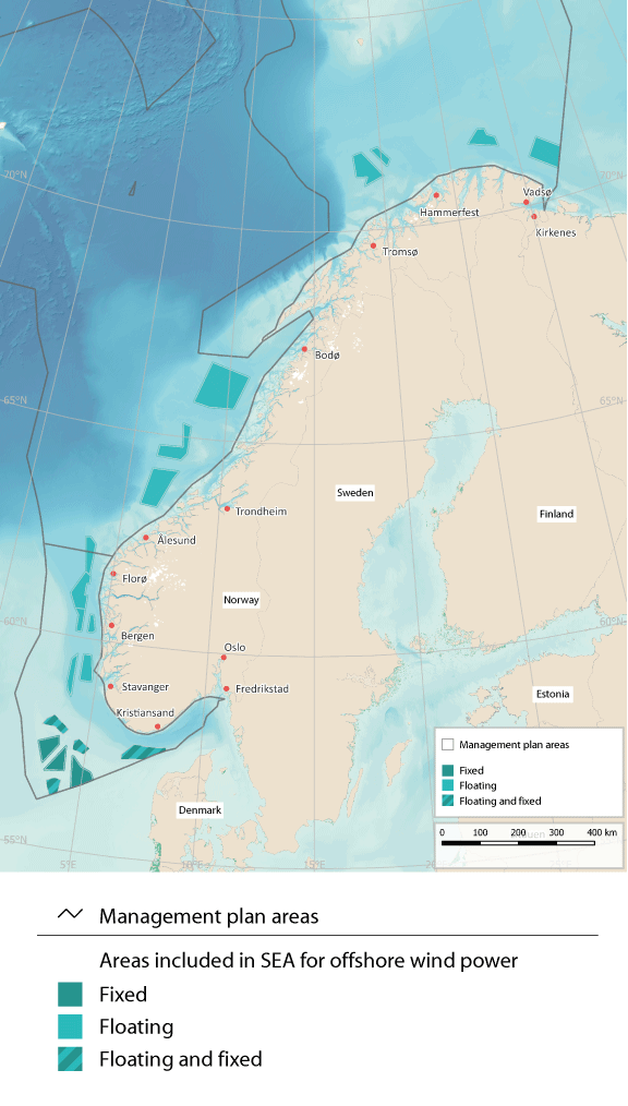
Figure 7.6 The twenty areas included in the strategic environmental assessments for offshore wind power.
Source: Norwegian Water Resources and Energy Directorate/Norwegian Environment Agency/Marine spatial management tool
7.2.5 CO2 storage under the seabed
CO2 capture, transport and storage technology (often referred to as CCS) is still in an early phase of development. Its success will be dependent on the development and establishment of complex value chains and extensive infrastructure requiring substantial investments.
Norway has adopted CCS regulations for the continental shelf, which apply to surveying and exploration of potential reservoirs under the seabed, to the exploitation of such reservoirs for CO2 storage, and to CO2 transport. Like the EU’s CCS Directive, the Norwegian regulations establish a system based on licences and permits. The Norwegian Offshore Directorate has mapped areas that are theoretically suitable for CO2 storage and has prepared a CO2 storage atlas for the Norwegian continental shelf.
As of March 2024, seven licences had been granted under Norway’s CCS regulations, including six exploration licences. One storage facility is currently being developed.
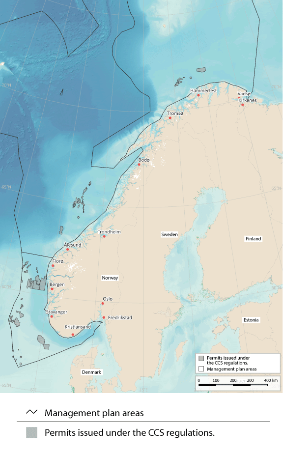
Figure 7.7 Areas allocated for CO2 storage under the seabed.
Source: Norwegian Offshore Directorate/Norwegian Environment Agency/Marine spatial management tool
7.2.6 Maritime transport
Maritime transport accounts for about 40 % of domestic transport work and more than 80 % of the volume of international transport. Maritime transport is thus very important both for the Norwegian business sector and for foreign trade. The volume of shipping (expressed as distance sailed) is expected to rise by about 40 % by 2040.
Areas are designated for traffic separation schemes, recommended routes and other regulatory measures for fairways under the Act relating to ports and navigable waters. Traffic separation schemes and recommended routes in Norway’s exclusive economic zone must also be approved by the International Maritime Organization (IMO). The introduction of traffic separation schemes and recommended routes along the coast has helped to move shipping further out from the coast, separate traffic streams in opposite directions and establish a fixed sailing pattern. This reduces the likelihood of collisions and groundings and makes it easier to intervene in the event of an accident.
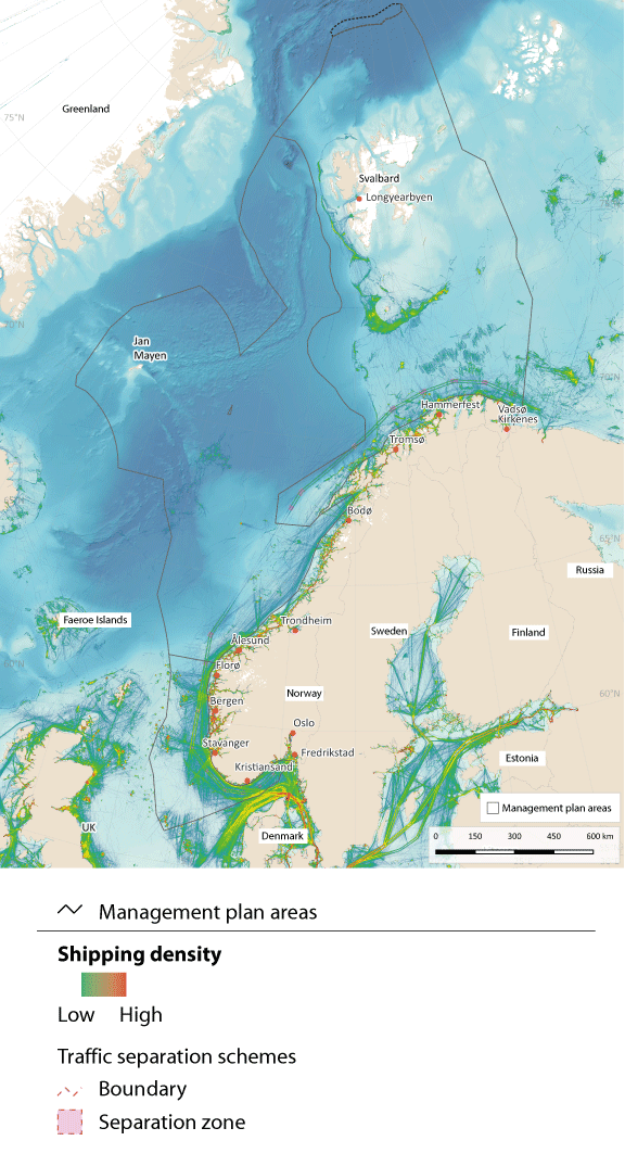
Figure 7.8 Map of shipping density in waters under Norwegian jurisdiction.
Source: Norwegian Coastal Administration/Norwegian Environment Agency/Marine spatial management tool
7.2.7 Seabed mineral activities
In accordance with the Seabed Minerals Act, an area must as a general rule have been officially opened for seabed mineral activities before licences can be issued to private companies.
The area of the Norwegian continental shelf that has been opened for seabed mineral activities lies in the Norwegian Sea and Greenland Sea and covers an area of 281 000 km2, as set out in a white paper published in 2023 (Meld. St. 25 (2022–2023)). This area is a long way from the mainland Norwegian coast, and other commercial ocean-based activity in the area is limited, consisting mainly of some fisheries and ships sailing through the area. The Government has decided that extraction from active hydrothermal structures will not be permitted, and this will help to limit any conflict with bioprospecting activities.
The processes that form minerals are also very important for biodiversity on the seabed in deep-water areas. The decision not to permit extraction from active hydrothermal structures and to protect such structures so that they are not damaged by activities in nearby areas will help to reduce the potential for conflict. During its consideration of the previous white paper on the ocean management plans, the Storting agreed that the need to protect distinctive and rare species and habitats in deep-sea areas should be assessed. Further investigations of species and habitats will be needed in any areas where there are plans to start up mineral activities.
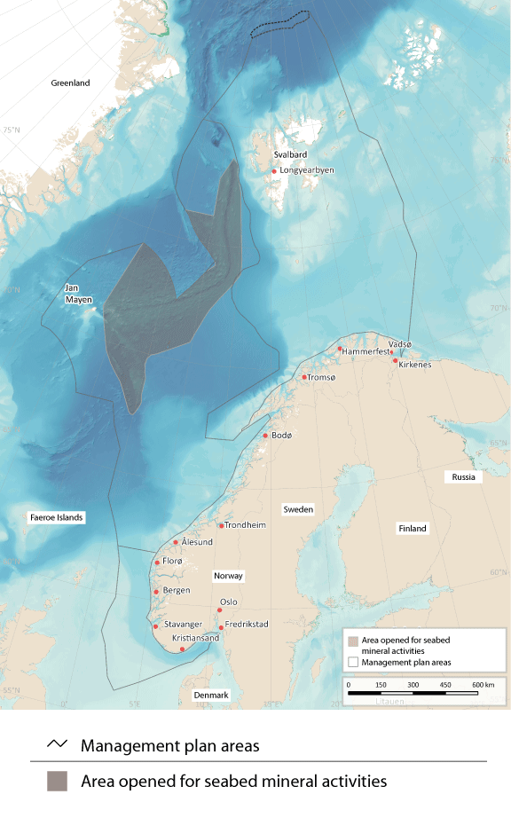
Figure 7.9 Map of the area of the Norwegian continental shelf that has been opened for seabed mineral activities.
Source: Norwegian Offshore Directorate/Norwegian Environment Agency/Marine spatial management tool
7.2.8 Bioprospecting
Bioprospecting is the systematic search for organisms, genes and molecules that could provide key components for various products and processes in medicine, the process industries, food production and other sectors. Such activities are already taking place, and as new sampling technology is developed, larger parts of the oceans will be of interest for bioprospecting.
Marine bioprospecting is of particular interest in northern seas because they are home to many species that are specialised to survive extreme and often changeable conditions. Along the Mid-Atlantic Ridge, there are hydrothermal vent fields that emit plumes of hot fluids. The living organisms found in such an extreme deep-water environment also have extreme properties. Microorganisms and biomolecules can be harvested for industrial and medical uses from hydrothermal vent fields.
Both the Marine Resources Act and the Nature Diversity Act could be used to regulate bioprospecting, and any regulation of the use of specific areas for bioprospecting would be introduced using one or both pieces of legislation. Norway has no current plans to designate specific areas for bioprospecting, and areas where there are organisms that might be possible to exploit through bioprospecting in the future have not yet been identified.
7.2.9 Routes for submarine cables
Submarine communications cables carry large volumes of data traffic. For example, almost all internet data traffic between islands and continents is transferred by cable. In Norwegian waters, the network of communications cables will be expanded and they will occupy larger areas of the seabed as the volume of data traffic rises.
When new subsea cables are being planned on the Norwegian continental shelf, the Ministry of Digitalisation and Public Governance is responsible for coordinating input from the authorities. Article 79 of the Convention on the Law of the Sea is applicable when new submarine cables and pipelines are laid on the Norwegian continental shelf.
The Norwegian National Coastal Administration is responsible for coordinating applications for new submarine communications cables in Norway’s territorial waters. Anyone planning to lay submarine cables in territorial waters is required to apply for a permit under the Act relating to ports and navigable waters. Information on new communications cables must be forwarded to the Norwegian Mapping Authority for inclusion on charts.
Norway has submarine power cables from the mainland to island communities, from the mainland to other countries (interconnectors), and from the mainland to certain petroleum installations. There are four subsea interconnectors between Kristiansand and Denmark, one between Feda and the Netherlands, one between Feda and Germany and one between Kvilldal and the UK.
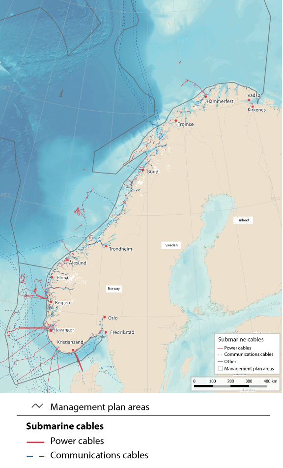
Figure 7.10 Map of submarine communications and power cables.
Source: Norwegian Water Resources and Energy Directorate/Norwegian Environment Agency/Marine spatial management tool
The installations on the oil and gas fields Valhall, Gjøa, Troll A, Ormen lange, Snøhvit, Goliat, Martin Linge, Johan Sverdrup, Edvard Grieg, Ivar Aasen, Gina Krog and Sleipner Øst are all now supplied with power from shore. Infrastructure for power from shore for the platforms on Oseberg, Troll B and C, Yggdrasil, Draugen og Njord and to the onshore facility Hammerfest LNG is under construction. Routes for power cables for use by the petroleum industry are designed to minimise inconvenience for other users of the relevant areas.
The development of offshore wind power also requires the construction of associated infrastructure. It will be possible to connect offshore wind power to the mainland, other countries and other offshore industrial installations, in the same way as for petroleum installations. The development of grid facilities offshore requires a licence under section 3-2 of the Offshore Energy Act.
7.2.10 Offshore military shooting and exercise areas
Offshore military shooting and exercise areas are essential to the Norwegian Armed Forces’ operational activities and for national emergency preparedness and crisis management capabilities.
New weapons systems and exercise concepts have resulted in a need to revise the system of offshore shooting and exercise areas. The deteriorating security policy situation has also made it even more important to ensure that the Armed Forces maintain access to exercise areas along the whole Norwegian coast. This includes Finnmark, the northernmost county, where there are currently no offshore military shooting and exercise areas. In addition, expanding the size of shooting areas will facilitate coexistence with other interests and industries by making it easier for the Armed Forces to adjust their activities to those of other sectors.
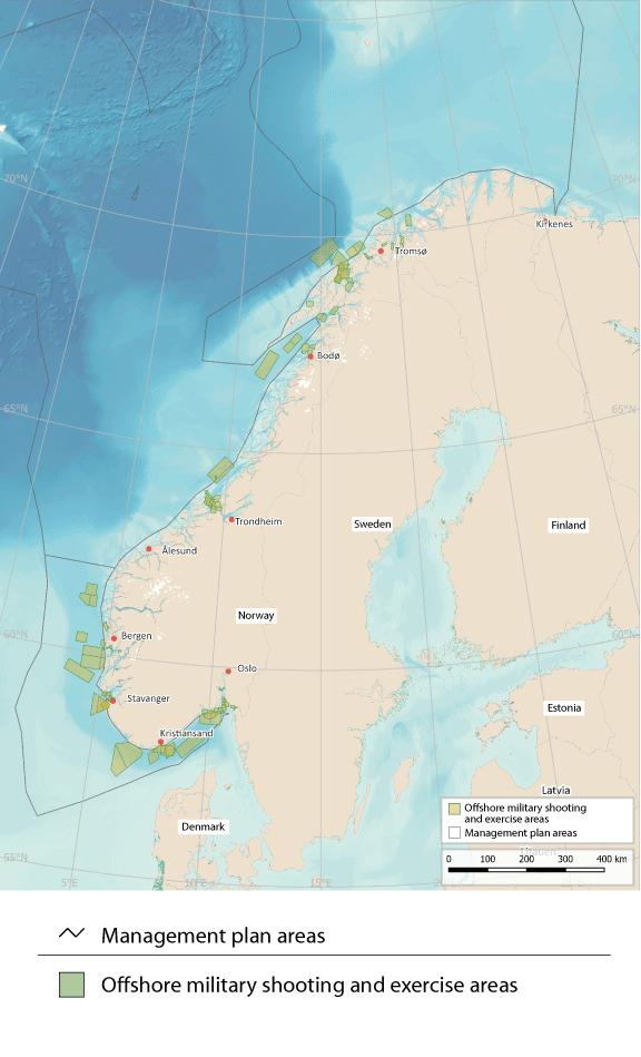
Figure 7.11 Offshore military shooting and exercise areas for the Norwegian Armed Forces
Source: Norwegian Armed Forces/Norwegian Environment Agency/Marine spatial management tool
7.2.11 The conservation of areas of special importance for marine biodiversity
Marine protection under the Nature Diversity Act and area-based conservation under the Marine Resources Act are tools for safeguarding areas where there are important ecosystems, habitats and species. The purpose of these tools is to ensure that areas are managed in a way that maintains their conservation value for the future. To achieve this, it must be possible to regulate pressures on conservation areas, and to implement active conservation measures where necessary. Any restrictions imposed on activity in such areas must be proportional to the purpose of protection.
Marine protected areas established under the Nature Diversity Act may extend up to 12 nautical miles beyond the baseline (up to the territorial limit). Around Svalbard, important marine species and habitats are protected where they are included in the marine parts of the national parks and nature reserves established under the Svalbard Environmental Protection Act.
In addition to the areas that are protected under these two Acts, the Marine Resources Act can be used to introduce area-based conservation measures in all Norwegian waters and on the Norwegian continental shelf. The Government is now drafting a new act that will provide the legal authority to establish marine protected areas in all Norwegian waters beyond the 12-nautical-mile limit.
Norway has been working for many years to safeguard marine areas and their species and habitat diversity for the future. In 2004, a broad-based advisory committee identified 36 marine areas along the coast for further evaluation, and current efforts are based partly on the committee’s recommendations. By the end of 2023, 17 marine protected areas and four national parks including substantial marine areas had been established under the environmental legislation, and in addition area-based conservation measures had been introduced for 18 coral reef areas under the Marine Resources Act. Marine conservation measures were further discussed in the white paper Norway’s integrated plan for the conservation of areas of special importance for marine biodiversity (Meld. St. 29 (2020–2021). A review of relevant area-based conservation measures has also been started based on the criteria for other effective area-based conservation measures (OECMs) adopted by the Convention on Biological Diversity. The aim is to identify which conservation measures, particularly relevant fisheries management measures, can be included when Norway reports to the Convention and other international forums on progress towards the conservation target set out in the Global Biodiversity Framework.
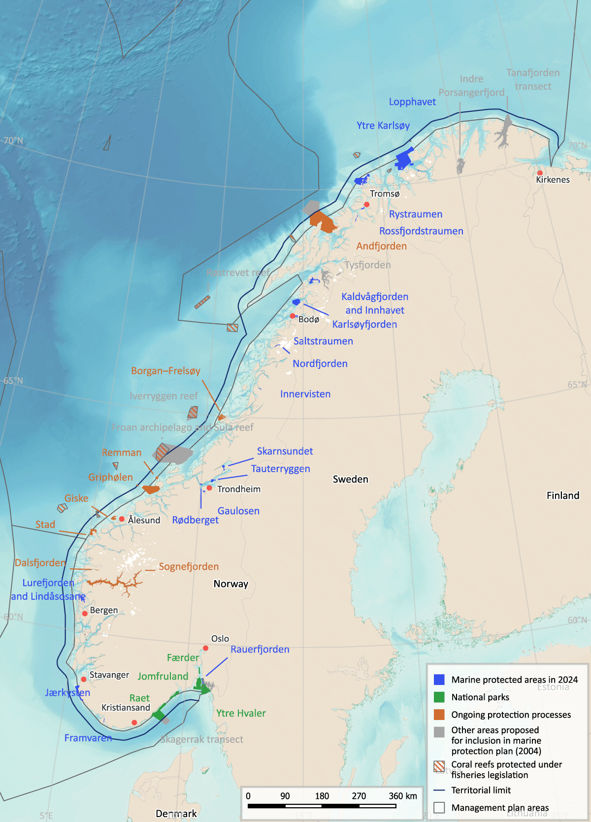
Figure 7.12 Existing and planned marine protected areas and other area-based conservation measures around mainland Norway.
Source: Norwegian Environment Agency, Norwegian Mapping Authority and Directorate of Fisheries/Marine spatial management tool
7.3 Rising activity levels and coexistence between ocean sectors
Norway has long experience of enabling the fisheries industry, maritime transport and the petroleum industry to share marine space. The management plans increase predictability and facilitate coexistence between industries that are based on using the ocean and its natural resources. As emerging industries seek to find their place, it will become even more important to provide a framework for satisfactory coexistence between different activities.
The Government will present an industrial plan for Norway’s ocean areas.
7.4 Climate and environmental considerations as a basis for marine spatial management
The 2019 Global Assessment Report of the Intergovernmental Science-Policy Platform on Biodiversity and Ecosystem Services (IPBES) states that globally, land- and sea-use change is the direct driver that is causing the greatest losses of biodiversity. The Intergovernmental Panel on Climate Change (IPCC) highlights the importance of ecosystem conservation through area-based measures, including developing networks of protected areas on land and at sea, in the context of climate change adaptation.
Under the global Kunming-Montreal Global Biodiversity Framework, countries have committed themselves to a set of targets, including one to ‘ensure that all areas are under participatory, integrated and biodiversity inclusive spatial planning and/or effective management processes addressing land- and sea-use change, to bring the loss of areas of high biodiversity importance, including ecosystems of high ecological integrity, close to zero by 2030, while respecting the rights of indigenous peoples and local communities.’
The ocean management plans are intended to provide an overall balance between use and conservation, based on knowledge about the natural environment, ecological functions and the value and vulnerability of different areas together with information about economic activity now and forecasts for the future. The framework for petroleum activities determines which activities take place in specific geographical areas, and is a form of spatial planning that takes special account of environmental value and fisheries interests. The framework for petroleum activities is implemented under existing petroleum-sector legislation, and more generally, activities in each management plan area are regulated on the basis of existing legislation governing different sectors.
When planning and implementing ocean-based solutions to the problem of climate change, it will be important to assess how the potential for reducing emissions and enhancing carbon uptake can be realised in ways that safeguard marine ecosystems, limit conflict between different user groups and prevent piecemeal development of ocean areas.